Lordy Rodriguez: Landscapes

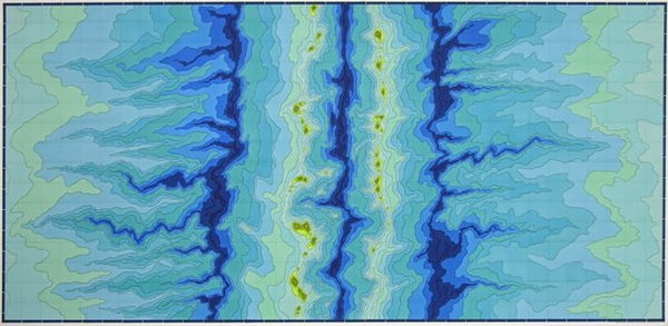
Lordy Rodriguez has made a career of drawing maps. His first cartographic project, representations of each of the United States as he wished them to be, came from a desire to envision his own personal sense of place and history. His newest drawings, based on techniques of topographical plotting, explore our reliance on the constructed realities of maps.
From Mapquest and GPS navigation systems to the Doppler 3000, we relate to our environment through abstracted representations. In Rodriguez’s world, jagged, swooping or swirling forms describe drifting silt dunes, volcanic island chains, underwater trenches and evidence of tectonic shifts. Pared-down to brightly colored contours — without symbols, direction, text or indicia of scale — his representations of place are abstracted beyond map-making traditions. Rather than tools for navigation or finding one’s place, these drawings are a dizzying realm where one is pulled in and becomes lost.
-

-
Lordy RodriguezVolcanic Island Chains, 2006ink on paper32 x 46 inches
81.3 x 116.8 cms -
Lordy RodriguezBarchan Dunes, 2006ink on paper32 x 46 inches
81.3 x 116.8 cms -
Lordy RodriguezRippled Hills (Geological Series), June 2005ink on paper32 x 46 inches
81.28 x 116.84 cms -
Lordy RodriguezLake Land (Geological Series), May 2005ink on paper32 x 46 inches
81.28 x 116.84 cms -
-
Lordy RodriguezShifted Lakes (Geological Series), June 2005ink on paper32 x 46 inches
81.28 x 116.84 cms -
Lordy RodriguezVolcano, 2006ink on paper48 x 48 inches
121.9 x 121.9 cms -
Lordy RodriguezUnderwater Trenches, 2006ink on paper36 x 72 inches/91.4 x 182.9 cm
-
Lordy RodriguezSalt Flat Desert Valley, 2006ink on paper3 panels, 60 x 36 inches each